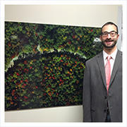
I use aerial photography of trees for my PhD research in biology. By taking imagery of the same trees over a period of time, I document the progression of leaf development and senescence. Using these data, I can study effects of microclimate and species, and make connections to the larger phenomena of climate change. In addition to a valuable environmental monitoring tool and fodder for computer analysis, aerial photography of trees is beautiful in its own right, exemplified by this image of Bartlett Experimental Forest in New Hampshire, at the peak of fall colors.
The image, known as an orthophoto, was created by combining 116 digital images, in such a way to approximate an overhead perspective at every point. Therefore the image is effectively a map of the forest, oriented so that north corresponds with up. An instrument tower is visible to the east of the center line, in the southern half of the image, where measurements of forest carbon sequestration have been made continuously since 2003, as part of the AmeriFlux network, and camera images of the forest canopy have been collected since 2005 for the PhenoCam network.
Bartlett Experimental Forest, September 24, 2014
Stephen Klosterman
PhD Candidate, Richardson Lab